LA County Planning offers maps free to download in PDF format (‘as is’ and at full size). Visit the LA County Internet Disclaimer webpage for more information on terms.
- First Supervisorial District – 2021 – Download Map– (Revised Jan 2022)
- Second Supervisorial District – 2021 –Download Map – (Revised Jan 2022)
- Third Supervisorial District – 2021 – Download Map– (Revised Jan 2022)
- Fourth Supervisorial District – 2021 – Download Map– (Revised Jan 2022)
- Fifth Supervisorial District – 2021 – Download Map– (Revised Jan 2022)
***NOTE: These reflect the LA County Supervisorial Districts after 2021 redistricting.
The following maps can also be downloaded in PDF format (‘as is’ and at full size):
- Cities and Supervisorial Districts – 2021 – Countywide (1” = 2 miles, 53” x 41”) – Download Map – (Created 12-20-2021)
- LA County Public Works Map Catalog for individual Supervisorial District Maps – Learn More
***Supervisorial District Maps reflecting the district boundaries established December 15, 2021.
The following maps can be downloaded in PDF format (‘as is’ and at full size), free of cost:
- T02 - Significant Ecological Areas, Countywide (adopted 2015) (1” = 2 miles, 53” x 41”) - Download Map (Revised Mar 2022)
- T03 - Zoned Districts - Countywide (1” = 2 miles, 53” x 41”) - Download Map (Revised Mar 2022)
- T04 - Highway Plan - North (no longer available) - Master Plan of Highways layer is available using GIS-NET Public.
- T05 - Highway Plan - South (no longer available) - Master Plan of Highways layer is available using GIS-NET Public.
- T06 - ZIP Codes - Countywide (1” = 2 miles, 53” x 41”) - Download Map (Revised Mar 2022)
The following maps can also be downloaded in PDF format (8.5” x 11” size), free of cost:
Note: These maps are current as of time prepared and may not reflect amendments or other changes to Community Standards Districts, which have occurred since last update (January 2018).
- Acton – Download Map
- Agua Dulce – Download Map
- Agua Dulce – Ridgelines – Download Map
- Altadena – Download Map
- Altadena – Ridgelines – Download Map
- Altadena – Lake Ave Mixed Use Center Area – Download Map
- Avocado Heights – Download Map
- Avocado Heights – Equestrian – Download Map
- Avocado Heights – Valley Blvd – Download Map
- Baldwin Hills – Download Map
- Baldwin Hills – Area Specific Standards (1) – Download Map
- Baldwin Hills – Area Specific Standards (2) – Download Map
- Castaic – Download Map
- Castaic – Ridgelines – Download Map
- Castaic – Castaic Creek – Download Map
- Castaic – Hasley Canyon – Download Map
- Castaic – Newhall Ranch SP – Download Map
- Castaic – Northlake SP – Download Map
- Castaic – Trucking District – Download Map
- Castaic – Val Verde – Download Map
- Castaic – Violin Canyon – Download Map
- Cerritos Island – Download Map
- Chapman Woods – Download Map (ADDED December, 2023)
- East Los Angeles – Download Map
- East Los Angeles – Comm / Residential Mixed Use – Download Map
- East Los Angeles – Union Pacific – Download Map
- East Los Angeles – Whittier Blvd – Download Map
- East Pasadena – East San Gabriel – Download Map (UPDATED December, 2023)
- East Rancho Dominguez – Download Map
- East Rancho Dominguez – Subareas – Download Map
- Elizabeth Lake and Lake Hughes – Download Map
- Elizabeth Lake and Lake Hughes – Ridgelines – Download Map
- Florence-Firestone – Download Map
- Florence-Firestone – Florence Ave – Download Map
- Florence-Firestone – Roseberry Park – Download Map
- Green Valley – Download Map
- Juniper Hills – Download Map
- La Crescenta – Montrose – Download Map
- La Crescenta – Montrose – Foothill Blvd – Download Map
- Lake Los Angeles – Download Map (Added January, 2024)
- Leona Valley – Download Map
- Leona Valley – Ridgelines – Download Map
- Rowland Heights – Download Map
- San Francisquito Canyon – Download Map
- San Francisquito Canyon – Ridgelines – Download Map
- San Francisquito Canyon – San Francisquito Creek – Download Map
- Southeast Antelope Valley – Download Map (UPDATED January, 2024)
- Southeast Antelope Valley – Palmdale Blvd – Download Map
- Southeast Antelope Valley – Pearblossom Hwy – Download Map
- Santa Monica Mountains North Area – Download Map
- Santa Monica Mountains North Area – Ridgelines – Download Map
- Santa Monica Mountains North Area – Malibou Lake – Download Map
- Santa Monica Mountains North Area – Topanga Canyon – Download Map
- South San Gabriel – Download Map
- Stonyvale – Download Map
- Three Points – Liebre Mountain – Download Map
- Twin Lakes – Download Map
- Walnut Park – Download Map
- West Athens – Westmont – Download Map
- West Athens – Westmont – Comm / Res Mixed Use – Download Map
- West Athens – Westmont – Senior Citizen Density Bonus – Download Map
- Willowbrook – Download Map
- West Rancho Dominguez – Victoria – Download Map
***NOTE: These maps are current as of time prepared and may not reflect amendments or other changes to Community Standards Districts, which have occurred since last update (January 2018).
The following maps can also be downloaded in PDF format (‘as is’ and at full size, with the exception of areas marked with an asterisk, which are offered at half-size), free of cost:
County covered by Area, Community or Neighborhood Plan. Scale – various (from 1” = 400’ to 1” = 8,000’) depending on size of area. Size – various (21.5” high by 38.5” wide to 43” high by 73” wide). Features: parcel level detail, major streets named, and general plan land use policy classifications.
Note: These maps are current as of time prepared and may not reflect amendments or other changes to land use policy map, which have occurred since last update (December 30, 2014).
Please click here for land use policy maps from our General Plan. These were updated in 2025 using an 8.5 x 11” format. We are in the process of creating larger, more detailed versions of these maps.
- Antelope Valley Area Plan maps – link to project page is here, and .zip file for land use policy maps is here
- Marina Del Rey Land Use Plan– (1” = 250’, 56” x 41”) – Download Map
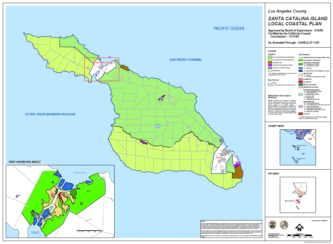
- Santa Catalina Island Local Coastal Plan / Specific Plan– (1” = 2,500’ , 56” x 41”) – Download Map
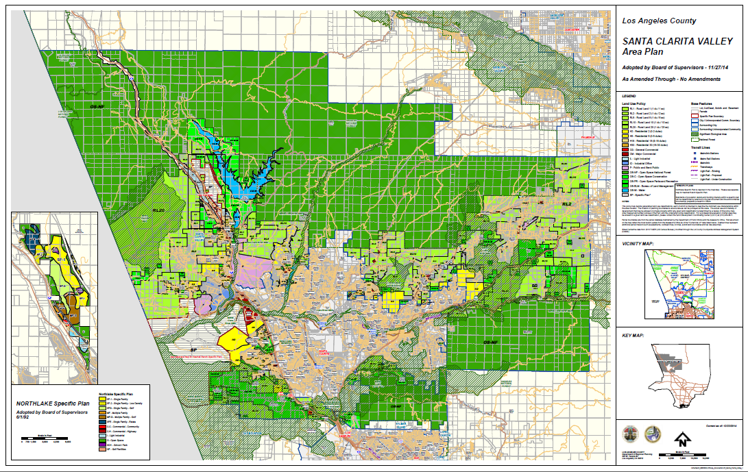
- Santa Clarita Valley Area Plan / Northlake Specific Plan – (1” = 3,500’ , 65” x 41”) – Download Map
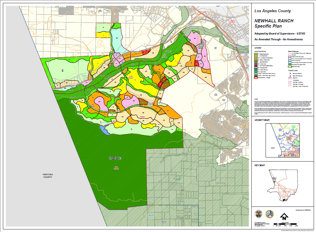
- Newhall Ranch Specific Plan (SCV)– (1” = 1,000’ , 56” x 41”) – Download Map
- Santa Monica Mountains Local Coastal Program – East Portion– (1” = 1,000’ , 71” x 41”) – Download Map
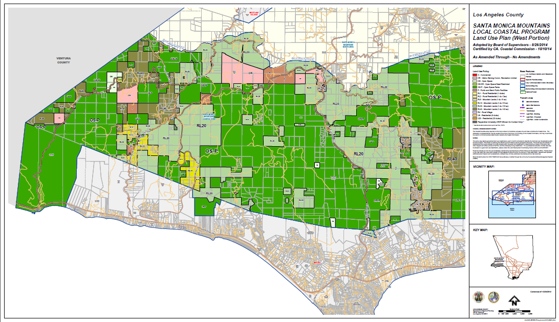
- Santa Monica Mountains Local Coastal Program – West Portion– (1” = 1,000’ , 71” x 41”) – Download Map
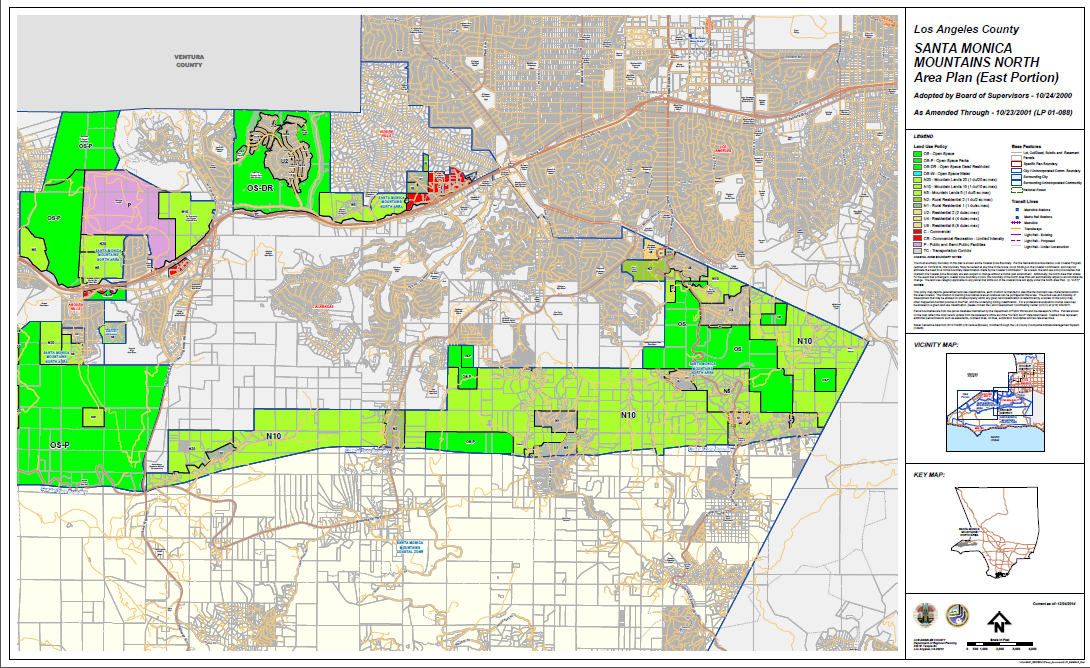
- Santa Monica Mountains North Area Plan – East Portion– (1” = 1,000’ , 67” x 41”) – Download Map
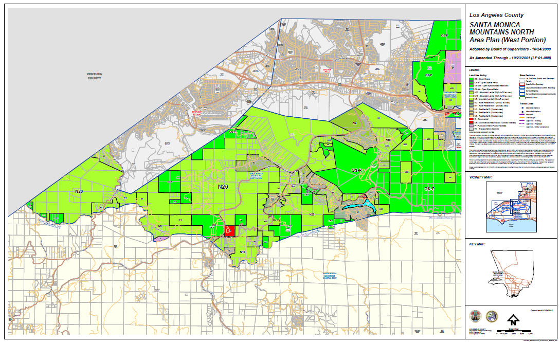
- Santa Monica Mountains North Area Plan – West Portion– (1” = 1,000’ , 67” x 41”) – Download Map
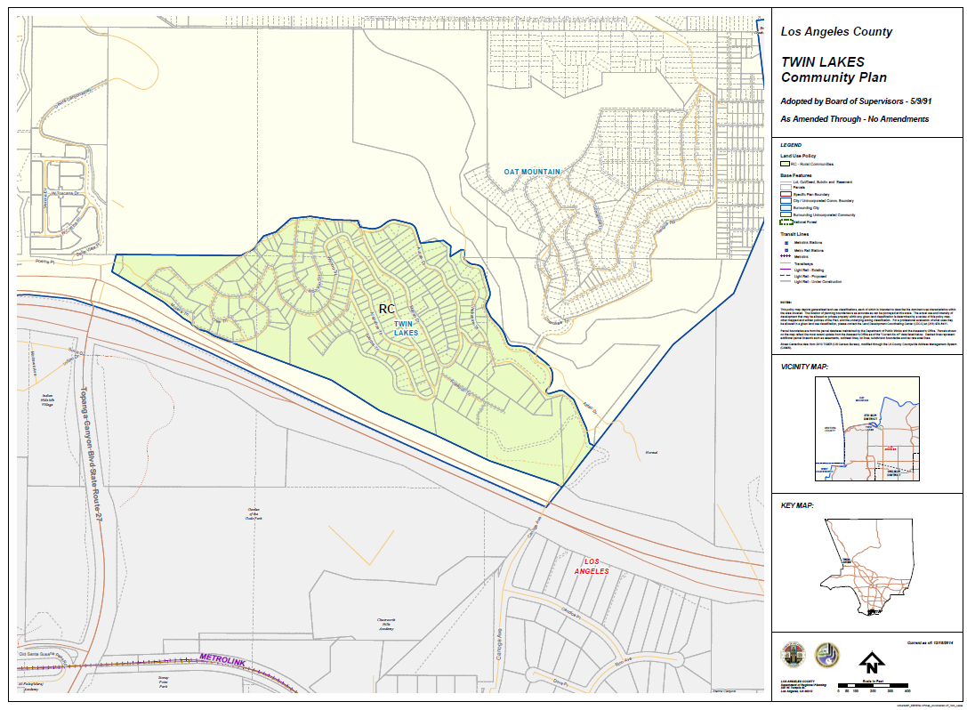
- Twin Lakes Community Plan– (1” = 100’ , 56” x 41”) – Download Map
COMMUNITY ZONING MAPS
The following maps can be downloaded in PDF format (‘as is’ and at full size), free of cost:
These maps are organized by Planning Area.
Please use the Planning Areas Lookup app to determine which Planning Area contains a specific community.
All maps are 56”x41”, unless otherwise indicated.
All maps updated April 2016, unless otherwise indicated.
IMPORTANT NOTE: Some of the Zoning and Land Use Policy PDF maps below may not reflect the most current zone changes or plan amendments. These maps are current as of time prepared and may not reflect amendments or other zone changes, which have occurred since posted. LA County Planning makes no warranty, representation or guarantee as to the content, sequence, accuracy, timeliness or completeness of any of the data provided herein. This information is for reference purposes only and should be used as a guide to finding zoning and other related information. For the most current and accurate depiction of these maps, please visit Interactive Web Mapping Applications webpage.
Contact us at info@planning.lacounty.gov for more information.
- Antelope Valley – East (68” x 41”) – Download Map
- Antelope Valley – South (73” x 41”) – Download Map (UPDATED – December, 2018)
- Antelope Valley – West (68” x 41”) – Download Map (UPDATED – May, 2020)
- San Clemente Island – Download Map
- Santa Catalina Island – Download Map
- Avocado Heights – Download Map
- Charter Oak – Download Map (UPDATED – May, 2020)
- Covina Islands – Download Map
- East Azusa – Download Map
- East Irwindale – Download Map
- East San Dimas – Download Map
- Glendora Islands – Download Map
- Hacienda Heights – Download Map (UPDATED – July, 2017)
- North Claremont – Download Map
- North Pomona – Download Map
- Northeast La Verne – Download Map
- Northeast San Dimas – Download Map
- Rowland Heights – Download Map (UPDATED – May, 2020)
- South Diamond Bar – Download Map
- South Walnut – Download Map
- Valinda – Download Map
- Walnut Islands – Download Map
- West Claremont – Download Map
- West Puente Valley – Download Map
- West San Dimas – Download Map (UPDATED – April, 2017)
- Bandini Islands – Download Map
- Cerritos Islands – Download Map
- La Habra Heights Islands/ Gateway Islands – Download Map
- Long Beach Island – Download Map
- Lynwood Island – Download Map
- North Whittier – Download Map
- Rancho Dominguez – Download Map
- South Whittier – Sunshine Acres – Download Map
- West Whittier – Los Nietos – Download Map (UPDATED – April, 2017)
- East Los Angeles – Download Map (UPDATED – May, 2020)
- East Rancho Dominguez – Download Map
- Florence – Firestone – Download Map (UPDATED – May, 2020)
- W Athens – Westmont – Download Map (UPDATED – June, 2020)
- W Rancho Dominguez – Victoria – Download Map (UPDATED – April, 2017)
- Walnut Park – Download Map
- Willowbrook – Download Map (UPDATED – December, 2018)
- Kagel / Lopez Canyons – Download Map
- Oat Mountain – Download Map
- Sylmar Island – Download Map
- Twin Lakes – Download Map
- Universal City – Download Map
- West Chatsworth – Download Map
- Westhills– Download Map
- Santa Clarita Valley (65” x 41”) – Download Map (UPDATED – December, 2018)
- Pepperdine University – Download Map
- Santa Monica Mountains Coastal Zone – East (63” x 41”) – Download Map (UPDATED – March, 2018)
- Santa Monica Mountains Coastal Zone – West (63” x 41”)
- – Download Map (UPDATED – March, 2018)
- Santa Monica Mountains North Area – East (63” x 41”)
- – Download Map
- Santa Monica Mountains North Area – West (63” x 41”)
- – Download Map
- Alondra Park – Download Map
- Del Aire – Download Map
- Hawthorne Island – Download Map
- La Rambla – Download Map
- Lennox – Download Map
- West Carson – Download Map (UPDATED – May, 2020)
- Westfield – Download Map
- Altadena – Download Map
- East Pasadena – East San Gabriel – Download Map
- Kinneloa Mesa – Download Map
- La Crescenta – Montrose – Download Map
- San Pasqual – Download Map
- South El Monte Island – Download Map
- South Monrovia Islands – Download Map
- South San Gabriel – Download Map
- South San Jose Hills – Download Map
- Whittier Narrows – Download Map
- Ballona Wetlands – Download Map
- Franklin Canyon – Download Map
- Gilmore Island – Download Map
- Ladera Heights / View Park – Windsor Hills – Download Map
- Marina Del Rey – Download Map
- West Fox Hills – Download Map
- West LA (Sawtelle VA) – Download Map