Overview
The East San Gabriel Valley Area Plan (ESGVAP) was adopted by the County Board of Supervisors on May 21, 2024 and took effect on June 20, 2024. The ESGVAP is a long-range planning document for the 24 unincorporated communities of Avocado Heights, Charter Oak, Covina Islands, East Azusa, East Irwindale, East San Dimas, Glendora Islands, Hacienda Heights, North Claremont, North Pomona, Northeast La Verne, Northeast San Dimas, Rowland Heights, South Diamond Bar, South San Jose Hills, South Walnut, Valinda, Walnut Islands, West Claremont, West Puente Valley, West San Dimas, Pellissier Village, Unincorporated South El Monte, and Unincorporated North Whittier.
The project consists of the plan, land use change maps, implementing ordinance, and the environmental document.
Project Public Hearing Dates
- On August 9th, 2023 the Regional Planning Commission unanimously recommended approval of the East San Gabriel Valley Area Plan (ESGVAP) to the Board of Supervisors.
- On January 30th, 2024, the Board of Supervisors recommended approval of the ESGVAP.
To review the Project Materials, click here: https://planning.lacounty.gov/long-range-planning/east-san-gabriel-valley-area-plan/documents/
Project Description
The proposed East San Gabriel Valley Area Plan (Area Plan or Project) is an extension of the General Plan focused on the unique needs and characteristics of 24 unincorporated communities within the East San Gabriel Valley Planning Area. The purpose of the Area Plan is to enhance, guide, and support the long-term growth, development, and maintenance of these communities. The Area Plan consists of areawide goals and policies on land use, economic development, community character and design, conservation and natural resources, mobility, and parks and recreation. The Area Plan also includes community specific goals and policies for each community or grouping of communities. Zoning and land use policy map changes are also proposed as part of the Project to bring zoning and land use policy into conformance, accommodate growth near major transit stops and along major corridors, preserve natural resources, and implement the Housing Element Rezoning Program. In addition, zoning map changes are proposed for designated properties to clarify the applicability of the adopted Green Zones Ordinance. The Project also includes ordinance amendments to implement the goals and policies of the Area Plan and consists of new areawide regulations and updates to existing standards.
Fact Sheets and Frequently Asked Questions (FAQs)
- Frequently Asked Questions (English) (Español) (中文)
- Pellissier Village Fact Sheet (English) (Español)
- Avocado Heights Equestrian District Fact Sheet (English) (Español)
- Avocado Heights Zoning Fact Sheet (English)(Español) (Updated 6/29/2023)
- Unincorporated South El Monte Fact Sheet (English) (Español)
What is an Area Plan?
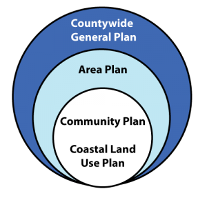
The General Plan provides goals and policies to achieve countywide planning objectives for the unincorporated areas, and serves as the foundation for all community-based plans, such as area plans, community plans, and coastal land use plans. An Area Plan will be prepared or updated for each of the County’s 11 Planning Areas and will provide opportunities to update local planning tools such as community plans, specific plans and community standards districts.

The Area Plan is a long term project that will take several years to complete. Project phases include research and data analysis; community outreach, workshops, and visioning; development of goals, policies and implementation actions; and preparation of the Area Plan and Environmental Impact Report.
Contact
LA County Planning
Community Studies East
(213) 974-6425
commplan@planning.lacounty.gov
Please contact the Community Studies East team for more information on the project. To be added to the project contact list, please contact the Community Studies East Section at commplan@planning.lacounty.gov .
