The Department of Regional Planning is aware of phishing emails targeting Los Angeles County residents. Please be advised that all official correspondence from Regional Planning is issued solely from [Name]@planning.lacounty.gov or donotreply@lacounty.gov email addresses. Communications from other domains are not affiliated with the Department and should not be treated as an official communication. The County will never request personally identifiable information via email or ask for payment or funds through wire transfer. If you receive a suspicious email or have concerns about its legitimacy, please do not respond or click any links. Instead, contact Regional Planning directly to verify at info@planning.lacounty.gov or (213) 974-6411.
If you were impacted by the recent fires and need assistance, please visit the Disaster Recovery page.
Los Angeles County is preparing Capital Improvement Plans (CIPs) for the East San Gabriel Valley (ESGV), Metro, South Bay, Westside, and West San Gabriel Valley (WSGV) Planning Areas, with completion anticipated in 2029. This website provides an overview of the CIPs, including the purpose of the CIPs and the CIP planning process. In addition, the website provides access to Planning Area-specific CIP pages, documents, events, surveys, and mailing list signups.
What is a CIP?
A CIP is a long-range planning document that identifies infrastructure needs, prioritizes potential infrastructure improvements, and explores potential funding strategies to help inform future infrastructure investment decisions over the next 5-10 years. In other words, a CIP is a planning tool that helps identify and prioritize potential infrastructure improvements for future consideration. Each CIP will primarily focus on mobility/transportation, sewer, and stormwater management infrastructure systems under the County’s jurisdiction within each specific Planning Area. Water and energy systems may be referenced at a high level for planning context and coordination purposes but are not a core part of the infrastructure analysis. Long-term infrastructure resilience and climate-related challenges will also be considered as part of the CIP development process.
Why Are We Creating CIPs?
The General Plan organizes the County unincorporated communities into 11 Planning Areas and requires the development of a CIP for each area as part of its implementation program. In recent years, the Board of Supervisors adopted Area Plans for the unincorporated communities of several Planning Areas throughout the County. These Area Plans included land use and zoning changes to accommodate over 56,000 additional housing units to address housing needs and future growth within these communities over the next 10 years. The CIPs are being prepared to help plan for infrastructure improvements needed to support existing communities, future growth, and long-term infrastructure resilience to climate change within each Planning Area.
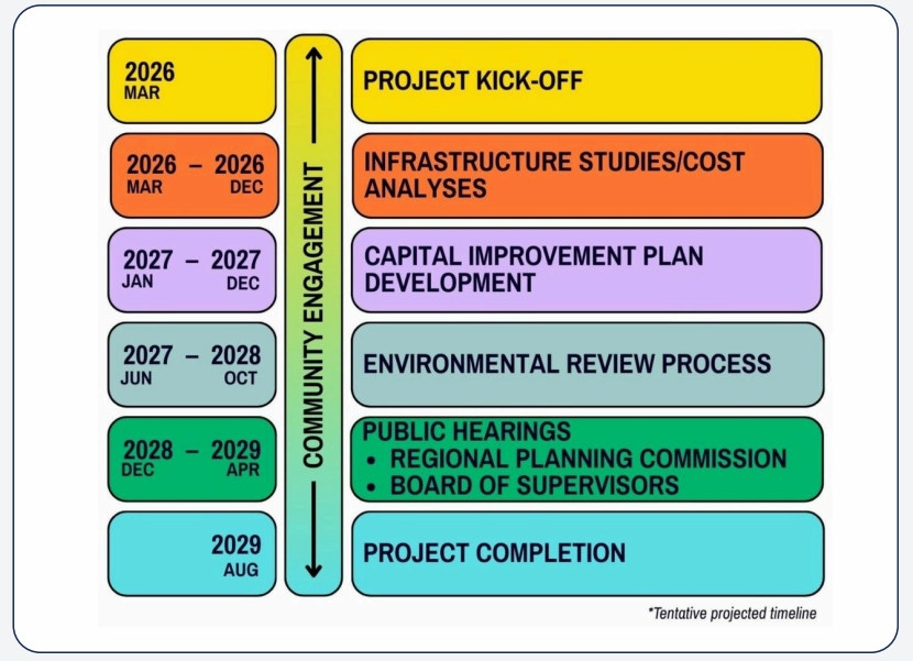
CIP Development Process
LA County Planning (DRP), in collaboration with the Department of Economic Opportunity (DEO), Chief Sustainability Office (CSO), Public Works (DPW), and other County departments, will develop an individual CIP for the five Planning Areas to support equitable and resilient infrastructure planning.
The CIP work process includes reviewing available infrastructure data, identifying infrastructure needs, identifying and prioritizing potential infrastructure improvements, preparing planning-level cost estimates, exploring potential funding strategies, and preparing the draft and final CIPs for each Planning Area. Community engagement activities will occur throughout the CIP planning process to help identify local priorities and infrastructure needs.
The CIPs will be covered by Programmatic CEQA/NEPA documents to evaluate environmental impacts of the proposed CIPs. The CIPs amend the County General Plan and will be reviewed through public hearing processes before the Regional Planning Commission and Board of Supervisors for final adoption.
Website Organization and Planning Area CIP Pages
The main navigation menu above provides two tabs that group each Planning Area CIP by geographic location within LA County. The Metro, South Bay, and Westside CIPs generally include unincorporated communities within the western and central portions of LA County. East and West San Gabriel Valley CIPs generally include unincorporated communities within the eastern portion of LA County. The two CIP tabs provide area-specific information, maps, documents, events, surveys, mailing list signups, and other information related to that group of Planning Area CIPs.
The Documents, Events, and Community Survey tabs on the main navigation menu serve as the central location for shared project materials, outreach activities, public meetings, surveys, and other CIP-related information shared by all 5 CIPs.
Sign up for our Contact Lists
To receive periodic project updates and newsletters, please sign up for the mailing list that corresponds with your Planning Area.